


Lake Pátzcuaro's Dwindling Lake Presence
Lake Pátzcuaro’s Dwindling Lake Presence
With Google Earth Engine
With Google Earth Engine
Where
Where
Michoácan, Mexico
Michoácan, Mexico
When
When
June 2026
June 2026
Type
Type
Individual Class Project
Individual Class Project
Tools
Tools
Google Earth Engine
Inkscape
Google Earth Engine
Inkscape
Skills Used
Skills Used
Remote Sensing
Remote Sensing
Lakes are drying up all over the world, Lake Pátzcuaro is no different.
Lakes are drying up all over the world, Lake Pátzcuaro is no different.
Lakes are drying up all over the world, Lake Pátzcuaro is no different.

1972
1972
1972
2025
2025
WHY HERE?
WHY HERE?
Lake Pátzcuaro has a personal connection to me as my parents told me how small the lake has gotten compared to its size back in their childhood. During my class on remote sensing, we learned about some of the CORONA program, which photographed various parts of Earth from the 1960s to the early 1970s, including this specific lake (left) and proved my parents' point of it being significantly larger than it is today (right).
Lake Pátzcuaro has a personal connection to me as my parents told me how small the lake has gotten compared to its size back in their childhood.
During my class on remote sensing, we learned about some of the CORONA program, which photographed various parts of Earth from the 1960s to the early 1970s, including this specific lake (left) and proved my parents’ point of it being significantly larger than it is today (right).
Lake Pátzcuaro has a personal connection to me as my parents told me how small the lake has gotten compared to its size back in their childhood. During my class on remote sensing, we learned about some of the CORONA program, which photographed various parts of Earth from the 1960s to the early 1970s, including this specific lake (left) and proved my parents’ point of it being significantly larger than it is today (right).
This drastic change in appearance inspired me to explore this more and spread awareness through visualizations of the change in water presence between 2018 & 2025.
This drastic change in appearance inspired me to explore this more and spread awareness through visualizations of the change in water presence between 2018 & 2025.
FORMULA
FORMULA
With the focus being on the lake's water presence, the Normalized Differential Water Index (NDWI) is the best method to use as it highlights the water and avoids non-water areas by utilizing the green and near-infrared bands from the satellite data provided.
With the focus being on the lake’s water presence, the Normalized Differential Water Index (NDWI) is the best method to use as it highlights the water and avoids non-water areas by utilizing the green and near-infrared bands from the satellite data provided.
With the focus being on the lake’s water presence, the Normalized Differential Water Index (NDWI) is the best method to use as it highlights the water and avoids non-water areas by utilizing the green and near-infrared bands from the satellite data provided.

VEGETATION VIEW
NDVI - 500M Scale
VEGETATION VIEW
NDVI - 500M Scale

WATER VIEW
NDWI - 500M Scale
WATER VIEW
NDWI - 500M Scale
This NDWI color palette ranges between brown hues, indicating land areas, and blue hues demonstrating varying levels of water presence in an area. While there are other formulas that capture water elements, like the Normalized Differential Vegetation Index (NDVI), their primary focus is typically not on the water presence in bodies of water.
This NDWI color palette ranges between brown hues, indicating land areas, and blue hues demonstrating varying levels of water presence in an area. While there are other formulas that capture water elements, like the Normalized Differential Vegetation Index (NDVI), their primary focus is typically not on the water presence in bodies of water.
FINDINGS
FINDINGS
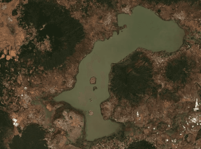
Between 2018 & 2025, the lake shrunk.
Between 2018 & 2025, the lake shrunk.
2018
2018

2019
2019

2020
2020

2021
2021

2022
2022

2023
2023
2024
2024

2025
2025

The change may not be obvious at first when looking at individual photos.
The change may not be obvious at first when looking at individual photos.

NDWI - 2KM Scale
NDWI - 2KM Scale
However, when you look at these photos through yearly composites using the NDWI in a timelapse, the shrinkage becomes more obvious. Most of this shrinkage occurred in the southern half of Lake Pátzcuaro.
However, when you look at these photos through yearly composites using the NDWI in a timelapse, the shrinkage becomes more obvious. Most of this shrinkage occurred in the southern half of Lake Pátzcuaro.
Possible Factors
Possible Factors
Droughts 🌵
Droughts 🌵
Mexico faced a drought in 2024. Without rainfall, lakes all over the country were not able to replenish their water. However, people still needed it for their crops and livestock.
Mexico faced a drought in 2024. Without rainfall, lakes all over the country were not able to replenish their water. However, people still needed it for their crops and livestock.
Overexploitation 🥑
Overexploitation 🥑
There has been an increase in avocado farmers across Michoácan, Mexico. Avocados are a water-intensive crop since they use a lot of water to help grow. This kind of overconsumption leads to lake water levels to decrease.
There has been an increase in avocado farmers across Michoácan, Mexico. Avocados are a water-intensive crop since they use a lot of water to help grow. This kind of overconsumption leads to lake water levels to decrease.
LIMITATIONS
LIMITATIONS
With there being many possible factors, there is no single solution ton the lake's overall decrease in water. It is also difficult to fully investigate these factors without being there in person. This includes looking into the kinds of privacy regulations and permissions needed on collecting data on peoples' crops, especially since this is all taking place in another country.
With there being many possible factors, there is no single solution ton the lake's overall decrease in water. It is also difficult to fully investigate these factors without being there in person. This includes looking into the kinds of privacy regulations and permissions needed on collecting data on peoples' crops, especially since this is all taking place in another country.
REFLECTION
REFLECTION
REFLECTION
Looking back, I would have liked to dive deeper into the factors related to different crops and investigate the growth of avocado farms in the surrounding area, as well as factors that help replenish water in the lake like rainfall to corroborate it with news reports on the droughts that Mexico has experienced in the past. That way, there is more context on the situation at hand for local government officials alongside Mexican residents to understand and plan an according solution to a problem that affects everyone in and out of Lake Pátzcuaro.
Looking back, I would have liked to dive deeper into the factors related to different crops and investigate the growth of avocado farms in the surrounding area, as well as factors that help replenish water in the lake like rainfall to corroborate it with news reports on the droughts that Mexico has experienced in the past. That way, there is more context on the situation at hand for local government officials alongside Mexican residents to understand and plan an according solution to a problem that affects everyone in and out of Lake Pátzcuaro.
Lake Pátzcuaro’s Dwindling Lake Presence
With Google Earth Engine
Where
Michoácan, Mexico
When
June 2026
Type
Individual Class Project
Tools
Google Earth Engine
Inkscape
Skills Used
Remote Sensing
Lake Pátzcuaro’s Dwindling Lake Presence
With Google Earth Engine
Where
Michoácan, Mexico
When
June 2026
Type
Individual Class Project
Tools
Google Earth Engine
Inkscape
Skills Used
Remote Sensing